Coordinates:
7°19′S 107°44′E
Go to Papandayan in Map
Located on the Indonesian Island of Java, sub-district Cisurupan, Garut region, West Java-Indonesia. This volcano is situated precisely 19 km from Garut city or 70 km southeast from Bandung. The mountain has it altitude of 2665 meters above sea level. Papandayan Mountain is located to the out most south of other mountain expanding in southern area of Bandung city. It is a very popular mountain.
 |
| The Papandayan crater view from residential |
Mount Papandayan is a large composite volcano, it is a crater-filled semi-active volcano. In 1772, one side of the volcano exploded and avalanche surrounding the 40 villages, destroying them completely. Over 3,000 villagers were killed. The volcano is still considered very dangerous and much of the surrounding area is restricted, especially considering there have been smoke, tremors and minor eruptions in 1923, 1942, plus several, all increasing in strength, in 2002.
The 1772 eruption has also truncated the volcano into a broad shape with two peaks and a flat 1.1 km wide of Alun-Alun crater in the middle. It looks like a twin volcano. One of the peaks is called Papandayan and the other is Mount Puntang.
Papandayan's Garut region is very exotic mountain, even from it's very first. Recorded in 1910,
Officieel Touristen Bureau, Weltevreden, the Government of the Netherlands East Indies, called the Garut as
Paradijs van het Oosten (heaven from the east). In this era, the various supporting facilities for easy access to visit such as the railroad was built to connect the Rail Station of Cibatu and Cikajang Station. Natural beauty and friendliness of the local peoples make Garut get the nickname Switzerland van Java by Charlie Caplin at his two tour in 1927 and 1933. Even the Dutch queen, Wilhelmina, has ever had a rest place in the city.
 |
| The Path to the Peak |
The peak of this most spectacular volcanoes in the province are easily reaches, because there are special road leading to the crater. The access path to the mountain is easy with any vehicle. Public buses take you only to within 9 km of the crater, so you either have to walk the rest of the way or take an ojek (private motorbike with driver).
 |  |  |  |
| Golden Crater | Baru Crater | Nangklak Crater | Manuk Crater |
At the summit of Mount Papandayan, there are famous four large craters, and it contains active fumarole fields. These craters is the Kawah Mas (Golden Crater), Kawah Baru (New Crater), Nangklak Crater, and Manuk crater. Craters are continued to release of steam.
 |
| Bubbling Mud Pools |
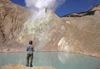
Tourists can walk across the crater and view phenomena such as bubbling mud pools, steam vents and sulfur deposits. The bubbling yellow crater (Kawah Papandayan or Papandayan Crater) is a popular view. Local people named it with Kawah Emas/Mas (or Golden Crater). Above that crater is the
Elfin forest and several meadows with the Javanese edelweiss.
 |
| Golden Crater |
 |
| Burned Trees |
Enjoying a hikes in Papandayan Mountain as well as the view of its natural beauty is a truly amazing experience. For those of you who hasn’t had the chance to visit Papandayan Mountain, you will see dried and burned trees and also smokes coming out from the ground and the mountains cracked wall. There are also other natural phenomenon that we usually encounter during the trip such as gas burst. What we should always be caution for is the soil which is very unstable.
 |
| New Crater as Lake Color on Papandayan Peak |
After that, we will arrive at the Lake of Colors (Telaga Warna). This lake has a greenish colors and gives out a strong gas stench. Actually this lake is a New Crater (known also as Kawah Baru). At the top of the mountain, our feelings should be filled with joy and happiness as if we were above the clouds for the moment. This is also one of the places where you can see the rare flower Edelweiss—this flower only grow on certain places and certain height—which most people would call it “the immortal flower” due to its nature which never withered and has its own signature aroma.
Mount Papandayans crater is probably one of the most spectacular mountain scenes on Java Island. There is a Cangkuang temple situated by Cangkuang Lake, which was a major discovery of archaeological value as it was the first of its kind found in West Java, dating back to the 8th century.
The reason for tourists to come here is because peoples can go from the bottom to the summit and then comes back down within a day only. So if people start early in the morning from Bandung, he would reached the top by mid-day, and then comes back at noon. Although, you should keep in mind the importance of a guide due to the mountain’s active status. This mountain erupted for sometime, leaving the surrounding nature burnt by the hot steam it emits. The damage made by the eruption turned the view of the surrounding in to a unique and rare to see. So, if you’re happen to be in Bandung or Garut, make sure to stop by, because it’s worthed every effort.
Torist who wants to go to the top has two ways up. First, they can go through Pengalengan, Bandung. And second, they can go through Cisurupan, which is in Garut district.
 |
| Papandayan Sunrise |
- If we wanted a faster trip, we can start from Garut and use Cisurupan road. This road had already been covered by asphalt, making it possible to use land transportation. Start from Garut city to the south in 30 minutes, then through Samarang toward Cisurupan. In Cisurupan junction, turn right along the village road (with good pavement) which continues uphill to an altitude of 2300 meters above sea level to the Nature Reserve of Papandayan with devious road and views of potatoes garden and a beautiful pine forest. But this way is only until we have reached uptown of Salada (Pondok Saladah). We are obliged to ask for a guide to lead us to the top.
- From Pengalengan district, Bandung; through the entrance which lies in the village of Pakenjeng, Pamulihan District which is the most common entrance often passed by the climbers. Arriving in the village of Pakenjeng, we still have to walk towards the feet of Papandayan mountain at the same time to the registration post. It's a fairly far distance, approximately 8-10 km (according to the information from local people) with uphill road.
View Larger Map
** indonesian mountain **


