Coordinates: 0°23′24″S 100°19′51″E
Goto Singgalang Mountain Map
 |
| Singgalang Seen from Marapi |
(Merapi in West Sumatra is different from Merapi in Central Java).
Mount Singgalang elevation is 2,877 m (9,439 ft). It have Hill Dipterocarp forest, Upper Dipterocarp forest, Montane forest, and Ericaceous forest (mountain forest). Hill Dipterocarp forest is a forest area that is located at altitude of between 300-750 meters. Upper Dipterocarp forest located at altitude of 750 to 1.200 meters, Montane forest located in the altitude of 1.200 to 1.500 meters. Whereas Ericaceous forest or mountain forest located higher than 1.500 meters. Here can be found edelweiss flower trees.
 |
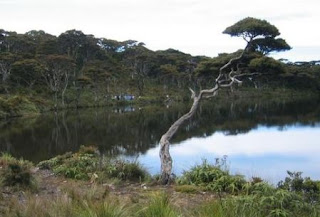
| Edelweiss Tree |
To reach Mount Singgalang from Outer regions, first take a bus to Bikittinggi from Padang. You can also start from any of Sumatra's major cities (i.e. you can start from Polonia Airport, Medan). From Bukittinggi, go to the bus terminal in the southeast part of the city.
There are three different climbing paths, that is:
- From Bukittinggi, locate a minibus to Kotabaru. (This route needed 6 hours to reach the peak).
- For those who take the route of ascent through district of Balingka, journey starts from Padang with public transports. Take down at Padang Luar (Bukittinggi), from Padang Luar towards Batu Tagak using the rural transportation route Panambatan village - Batu Tagak (Balingka district). The climbing starts from Batu Tagak. This ascent takes an average of 8 hours.
- As for who took the route of Toboh, journey also starts from Padang towards Padang Luar (Bukittinggi) then proceed towards Toboh. From Jorong Toboh village (Kenagarian Malalak) the climbing can be started. Normally need approximately 12 hours long.
 |
| Sianok Canyon at the Feet of Singgalang |
From Kotabaru, there are several route possibilities for accessing the main trail heading up to the peak of Singgalang. A local guide is certainly can gives great helps. From Kota Baru, take the road way to Pandai Sikek. Then take the trail (usually confusing) north through many fileds, farms, and settlement before reaching a small village. From the village, there is a trail heads west to another small village known as Pago Pago. From Pago Pago, a rough trail heads west up the ridge to the summit of Singgalang. The trail is challenging and rarely used, and you must duck and crawl under several low hanging trees.
Beside that, at Kotabaru/Kotobaru you can go to the Kotobaru market (Pandai Sikek intersection) in order to waiting for public transportation to the village of Tanjung, from here (as a starting point to climbs) takes about 2 hours walk to Pesanggrahan (now beside RCTI TV tower), which is also a place to report any ascents. You can also use the rural transportation (usually called the Cigak Baruak) of Suzuki Carry Minibus.
 |
| Talago Dewi (Lake Dewi) |
Tips:
- Sumatra is wet year round, and there is little temperature variance throughout the year. Typically, February and March are the driest months, and September through December, the wettest, but be prepared for heavy rains at any time of year.
- If you don't want to make the climb at night, climbing should be started not later than 01.00pm (13.00) local time. The leisurely trip takes about 3 hours toward the bivouac I. 15 meters before heading to the bivouac I, we will cut off the flow of the river which is the source of water during our stay in this area. But if you intend to ride in the morning (around 09.00), we can reach the bivouac II approximately at 16.00. In this area, if we want, many forest plants can be eaten, such as elephant fern, begonia, strawberry, and others. From bivouac II you can continue the journey towards the peak.
Reference: http://wisatasumatera.wordpress.com/
View Larger Map
** indonesian mountain **


3 comments:
Shopping in Bukittinggi Experience was fantastic for me because of the cheap items sold. I got so many batiks materials ,embroidery materials , silver wares ,wooden woodraft...I just dont know when to stop picking items after items.
.John
" Choose a job you love, and you will never have to work a day in your life."
-- travel jobs --
Its very informative and interesting article.all the points are very useful. Simple but very effective writing. Thanks for sharing such a nice post.
climb to the peak
When you reach Kathmandu never skip to visit Pokhra and Chitwan forest and others spots. Airport transportation Kathmandu is perfect for your trip.
Post a Comment